News & Events
3D MODELS OF SUDANIAN CITIES
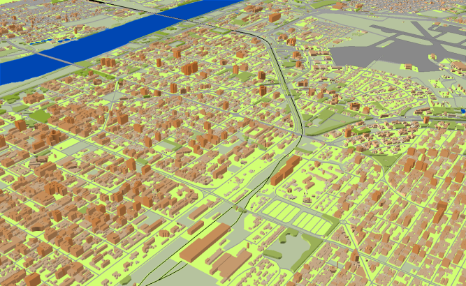
**data for RF planning:** [3D model][1] of Khartoum – 660 sq km including:
- [3D model][1] of Khartoum – 206 sq km; - [3D model][1] of Omdurman – 208 sq km; - [3D model][1] of Khartoum Bahri – 173 sq km; - [3D model][1] of Um Badda – 53 sq km; - [3D model][1] of South Khartoum – 15 sq km; - [3D model][1] of Karary – 5 sq km. [3D model][1] of Port Sudan – 60 sq km. [3D model][1] of Wad Madani – 49 sq km. **data for GIS project and WEB project:** [Map][6] of Khartoum – 660 sq km including:
- [Map][6] of Khartoum – 206 sq km; - [Map][6] of Omdurman – 208 sq km; - [Map][6] of Khartoum Bahri – 173 sq km; - [Map][6] of Um Badda – 53 sq km - [Map][6] of South Khartoum – 15 sq km - [Map][6] of Karary – 5 sq km [Map][6] of Port Sudan – 60 sq km
[Map][6] of Wad Madani – 49 sq km
Project package includes 3 types of data representation:
1. Vector data model provided as a composition of vector layers in ESRI ArcGIS or Mapinfo formats.
2. Raster data model presented in Geo-tif format and includes:
• Digital Elevation Model (DEM) (data placed in Height.tif file);
• Land Use Map (Clutter Model)
3. Service Data for RF planning tools:
• [Digital Terrain Model (DTM][10]);
• Land Use Map (Clutter Model) in matrix representation;
• Text labels;
• Vector layers.
[1]: https://visicomdata.com/products/data_for_wireless_planning/3d_models?lang=en [6]: https://visicomdata.com/products/geospatial_data?lang=en [10]: https://visicomdata.com/products/elevation_products?lang=en


Order product
Please, contact us directly if you have question
We always reply within 24 hours
Contact us
Please, contact us directly if you need any information