News & Events
2.5D or 3D geodata which one do you choose?
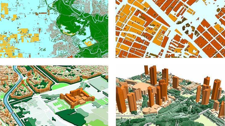
**2.5D GEODATA** *
From 5m to 10m resolution models.* *
Usually, it’s used for the suburb and rural areas.* *
Provide precise and cost-effective modelling of obstacles height over large areas.* *
Individual buildings footprints, trees, bridges etc. and their heights are not included.* - 2.5D buildings: buildings and buildings blocks with assigned height attributes, 3m-5m accuracy. - 2.5D vegetation: vegetation polygons with assigned height attributes, 5m accuracy. - DSM/DTM: 3-5m accuracy in terrain features. - SOURCES: 1.5-2.5 m resolution Stereo satellite imagery. **3D GEODATA** *
1-2-5 m resolution geodata for highly accurate networks planning.* *
All individual features of roofs and buildings construction are provided.* *
3D vegetation or individual trees are included.* - 3D buildings: 1-3 m accuracy in height, with small roof details. - 3D bridges: 1-3 m accuracy and detailed engineering construction. - 3D vegetation: detailed vegetation with assigned height attributes. - Clutter/land use: includes all land-use features and detailed vegetation layer. - SOURCES: 0.3-0.5-1 m resolution stereo satellite imagery, air photos, Lidar data. Send us your request for more information and free data samples of 3D and 2.5D models. [**
Our geodata catalogue includes over 4000 cities and 80+ countries.**][1] [1]: https://visicomdata.com/geodata-portfolio?lang=en&lang=en&lang=en


Order product
Please, contact us directly if you have question
We always reply within 24 hours
Contact us
Please, contact us directly if you need any information