RailGeoKit: Accurate mapping of railway networks
What is RailGeoKit?
RailGeoKit is a product developed by VISICOM — a comprehensive set of 3D and 2.5D digital maps tailored specifically to meet the needs of reliable 5G coverage planning for railway infrastructure.
The importance of RAN planning for railways
RAN (Radio Access Network) planning for GSM-R and 5G/FRMCS is critically important for next-generation railways, as it ensures:
- High-speed mobile communication
- Continuous coverage along all sections of the route
- Reliable signal transmission for control and safety systems
This is especially crucial in conditions such as:
- Tunnels, bridges, mountainous and remote areas
- High traffic density and complex infrastructure
5G Rail Corridors & FRMCS (Future Railway Mobile Communication System)
At the heart of the digital transformation of railways lies the concept of 5G rail corridors — specialized networks designed to provide reliable broadband communication for digital railway infrastructure.
Mapping a route to 5G rail corridors is
a key step in this process, enabling precise planning of network infrastructure to ensure full coverage and high quality of service.
- Support for FRMCS — the future international standard for railway communication
- Provision of broadband, reliable, and secure connectivity along railway lines
The goal of FRMCS is
to provide mobile network operators with all the necessary tools to deliver high-quality coverage and service in designated areas of railway infrastructure.
Key Challenges in network planning
- A vast and complex railway network with varying terrain and urban structures
- Lack of up-to-date, detailed, and accurate maps in many regions
- Difficulty in ensuring stable connectivity along the entire railway route
Key product features:
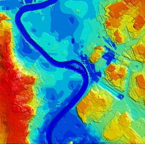
- Complete geodata coverage within a buffer zone of 500 m to 4 km. This zone serves as a dedicated corridor for the deployment of 5G base stations, antennas, and other equipment, ensuring seamless connectivity along the railway lines.
- High spatial accuracy ranging from 1 to 5 meters depending on project requirements.
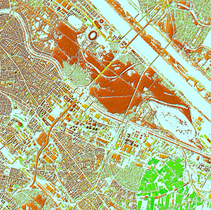
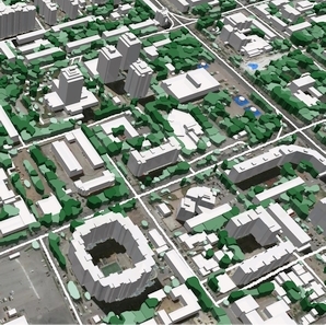
- All terrain features are included
- All artificial obstacles are included with 1-2m accuracy:
-
- Tunnels
- Bridges and overpasses
- Road and interchanges
- Buildings
- Trees
- Flexible area coverage – available upon request, from a single rail line to an entire region or country.
- Compatibility with all major radio and network planning systems.
RailGeoKit ADVANTAGES:
- Flexible pricing
The cost is calculated based on the coverage area and map type, allowing you to choose the most suitable package for your project budget - Pilot-friendly terms
Preferential pricing is available for the first pilot region or route, making it easy to test the product before scaling - Free format conversion
Map conversion into the required format is included in the base price — no extra fees. - One-year product support
Technical and usage support is provided for one year after delivery. - Update on demand
Maps can be updated upon request, ensuring long-term data relevance. - Free sample map fragment
A free sample of a railway section is available for evaluation — e.g. for Germany, Luxembourg, Switzerland, Spain, Australia, Italy, France, etc.
We guarantee
Our manager and production teams are customer-oriented professionals highly skilled in RF planning process. Our production and sales infrastructure allows to realize the projects of various difficulty, complexity and scope supporting high-level data quality
Precise and up-to-date mapping information
Detailed and high-resolution terrain
Delivery in any RF planning tool and GIS format
Extra-accurate 3D buildings
Flexible price fitted to customer budget
Flexible price fitted to customer budget
Data formats
Alcatel A955
ICS Telecom
MapInfo
Pathloss
ASCII XYZ
ER Mapper Raster
Aircom Asset
NetPlan
Microstation
Mentum Ellipse
Raster images
ENVI Image Format
Atoll Forsk
AutoCAD
Neva
Mentum Planet
TIFF and GeoTIFF
Generic Binary
CelPlanner
ESRI ArcGIS
Odyssey
Nokia NetAct
ERDAS Imagine Image


Order product
Please, contact us directly if you have question
We always reply within 24 hours