News & Events
3D MODEL FOR 5G PLANNING OF MONTREAL, CANADA
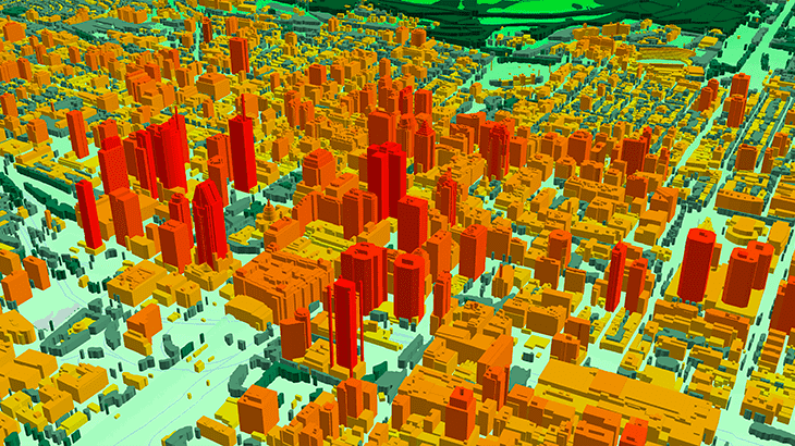
*3D model covers 50 km2 of the core city in [LOD2][3] quality.
* *3D model resolution: 1m or 2m.
* *3D geodata accuracy – 2-3 m in x,y,z.
* **Usually delivered layers:** - ✅ [Digital Terrain Model (DTM)][4] - ✅ Digital Surface Model (DSM) - ✅ Highly accurate 3D building vectors - ✅ Clutter/Land Use - ✅ 3D Obstacles - ✅ Vegetation - ✅ Road networks, water bodies, coastline Additional layers: Street names, Addresses [**☑ More information about 3D geodata for 5G planning.**][5]
**[ ☑ Our geodata catalogue includes over 1500 cities across 120 + countries.][6]**
**✉ Contact us to receive a free sample of the 3D city Model.** [1]: https://visicomdata.com/products/geodata_for_5g_planning?lang=en&lang=en [2]: https://visicomdata.com/products/3d_trees_canopy_model?lang=en&lang=en [3]: https://visicomdata.com/products/3d_maps/lod_2?lang=en&lang=en [4]: https://visicomdata.com/products/elevation_products/digital_terrain_model_dtm?lang=en&lang=en [5]: https://visicomdata.com/products/3d_geodata_for_5g_planning?lang=en&lang=en [6]: https://visicomdata.com/geodata-portfolio?lang=en


Order product
Please, contact us directly if you have question
We always reply within 24 hours
Contact us
Please, contact us directly if you need any information