News & Events
Brussels (Belgium) Geodata for 5G network planning and IoT
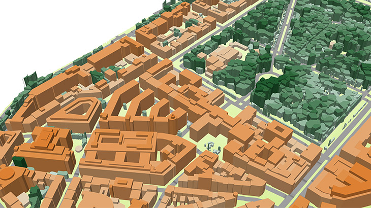
- 1m resolution 3d buildings with small roof details
- 1-2m in terrain features
- detailed vector vegetation up to separate trees
- derived from high resolution stereo images (0,3-0,5m resolution)
- tailored to mmWave frequencies characteristics and IoT requirements
- support of any customizable geodata formats **Brussels 3D geodata package for RF Planning contains:** Digital Terrain Model (DTM), Digital Surface Model (DSM), highly accurate 3D Buildings with roof details, 3D Vegetation and Bridges, Clutter/Land Use/Land Cover Model, Obstacles Heights (Clutter Heights) Model, Vector model, Transportation networks etc. **Brussels 3D geodata package for IoT** could be customized in any representation. The main data layers are 3d low-poly building footprints with assigned attributes of heights, vector vegetation up to alone standing trees with heights, detailed road network, engineering constructions as vectors (namely, bridges, overpasses etc). Download the **[brochure][3]** and **[free data sample of Brussels map package][2]** for more details. **[Our geodata catalogue][1]** includes over 4500 cities across 110+ countries. **Send us your request for more information** [1]: https://visicomdata.com/geodata-portfolio?lang=en"See our coverage of geodata " [2]: https://visicomdata.com/raw?id=12953&lang=en [3]: https://visicomdata.com/raw?id=12954&lang=en


Order product
Please, contact us directly if you have question
We always reply within 24 hours
Contact us
Please, contact us directly if you need any information