Across Africa, the need for accurate and accessible geospatial data is growing rapidly. Today, mapping is far more than a technical task — it underpins national planning, climate resilience, infrastructure development, and sustainable growth for millions of people.
According to the World Urbanization Prospects (UN DESA), and analyses by UNECA, Africa is experiencing one of the fastest and most significant urbanization processes globally. As highlighted in the Africa Urban Forum materials, the continent’s urban population may double by 2050, while major cities are becoming key engines of economic development, innovation, and social transformation.
This rapid growth presents both opportunities and challenges. Urbanization can drive job creation, infrastructure expansion, and improved quality of life — yet without modern planning and reliable data, it may also lead to inequality, unplanned expansion, and pressure on public services.
Geospatial information plays a central role in addressing these challenges. It provides a clear, accurate understanding of real conditions on the ground, supports informed decision-making, and enables countries to guide the development of cities that grow wisely and sustainably.
We strongly believe that geospatial data is essential. It helps countries understand their environment, manage rapidly growing cities (such as Abidjan, Lagos, or Dar es Salaam), respond to natural risks, and build a foundation for long-term progress.
We also support the message of Côte d’Ivoire’s Centre for Geographic and Digital Information (CIGN) who emphasizes that strong geospatial systems rely on:
- accessible and high-quality national datasets,
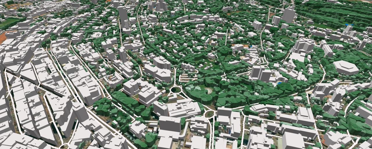
- updated land-use maps and 3D models,
- modern reference frameworks,
- integration of satellite imagery,
- effective cooperation between institutions,
- and trust in data for decision-making.
These principles fully align with VISICOM’s values and long-term work on the continent.
VISICOM’s Mission
At VISICOM, we believe that every country needs modern, reliable, and scalable geospatial data. Over the years, we have delivered a wide range of mapping solutions across Africa — from national 2D datasets to detailed 3D city models, clutter maps, population layers, and customized geospatial products.
Our approach is built on three core pillars:
1. Data tailored to local needs
We design our products based on what each country truly requires — whether for telecom development, infrastructure planning, environmental monitoring, or urban growth. Precision and consistency guide every dataset we create.
2. Technology and expertise that support the future
Our production workflow combines:
- the latest satellite imagery,
- advanced classification tools,
- multi-level quality control,
- and over two decades of experience in national-scale mapping.
This enables us to deliver high-quality data that governments and organizations can easily integrate into their systems and planning tools.
3. Collaboration above all
We believe meaningful progress comes from strong partnerships. We value transparent cooperation and support local teams in building sustainable, long-lasting geospatial ecosystems.
Why Geospatial Data Matters
Africa is changing rapidly — cities are expanding, climate risks intensify, infrastructure evolves, and digital services become essential. In this context, modern geospatial data is not a luxury — it is a necessity.
It enables better:
- land management,
- transportation planning,
- disaster preparedness,
- environmental protection,
- telecom connectivity,
- and urban development.
VISICOM is proud to contribute to these transformations by providing high-quality geospatial solutions and building strong, long-term partnerships across the continent.
Our approach is to deliver reliable geospatial solutions and support our clients and partners in implementing their sustainable development strategies — helping to shape a more connected, informed, and resilient Africa.
Geospatial data shapes the future — and VISICOM is here to help build it.
VISICOM has extensive experience in delivering 3D city models for urban and city planning across the African region, including the following countries: Algeria, Angola, Djibouti, Egypt, Equatorial Guinea, Ethiopia, Ghana, Kenya, Libya, Mali, Mauritius, Mozambique, Nigeria, São Tomé and Príncipe, Seychelles, Somalia, South Africa, Tanzania, Tunisia, Senegal, Sierra Leone, and Morocco.
VISICOM also has strong experience in regional planning projects covering the following countries: Algeria, Burundi, Ethiopia, Ghana, Guinea-Bissau, Mali, Somalia, Tunisia, Zambia, Senegal, Sierra Leone, and Morocco.
You may review sample test datasets for the following countries:
Uganda, Tunisia, Namibia, Mozambique, Morocco, and Ghana, as well as a 3D video presentation of Kampala (Uganda) for visual review.
Additional materials and detailed technical specifications can be provided upon request.

