News & Events
High precision 2D city map of West Bank cities
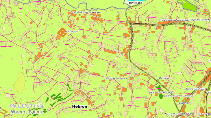
**[data for RF planning][6]:** [2D Regional Model][1] of Al-Ram (West Bank) – **3 sq km** [2D Regional Model][1] of Bethlehem (West Bank) – **17,9 sq km** [2D Regional Model][1] of Hebron (West Bank) – **48 sq km** [2D Regional Model][1] of Jenin City (West Bank) – **14,9 sq km** [2D Regional Model][1] of Jericho (West Bank) – **32,7 sq km** [2D Regional Model][1] of Nablus City (West Bank) – **46,6 sq km** [2D Regional Model][1] of Qalqilia (West Bank) – **8,7 sq km** [2D Regional Model][1] of Ramalla (West Bank) – **29 sq km** [2D Regional Model][1] of Salfit (West Bank) – **3,2 sq km** [2D Regional Model][1] of Tulkarem (West Bank) – **26,4 sq km** **[data for GIS project and WEB project][7]:** [Map][7] of Al-Ram (West Bank) – **3 sq km** [Map][7] of Bethlehem (West Bank) – **17,9 sq km** [Map][7] of Hebron (West Bank) – **48 sq km** [Map][7] of Jenin City (West Bank) – **14,9 sq km** [Map][7] of Jericho (West Bank) – **32,7 sq km** [Map][7] of Nablus City (West Bank) – **46,6 sq km** [Map][7] of Qalqilia (West Bank) – **8,7 sq km** [Map][7] of Ramalla (West Bank) – **29 sq km** [Map][7] of Salfit (West Bank) – **3,2 sq km** [Map][7] of Tulkarem (West Bank) – **26,4 sq km** [2D Regional model][1] is a medium-to-low-resolution database designed for large-area RF planning. It's the ideal solution in initial network planning and network planning in rural areas. [2D Regional RF map][1] of West Bank cities (2D city models) covers more than **230 sq.km**. We have used recent vintage imagery Sentinel of 1 m resolution to create 2 m resolution geodata.  [SRTM/ASTER DEM data][2] and available topo maps were processed for [DTM][3]/[DSM][4] production.  Clutter/Land Use/Land Cover are classified into different classes: classes of built-up areas, water classes, classes of landscape and vegetation. Land Use map was produced from multispectral satellite imagery by method of automatic classification with subsequent manual photo-interpretation and modification.  [2D Regional model][1] allows quickly visualize terrain and clutter over large areas or entire countries. It consists of the following integrated layers: [digital terrain model (DTM)][3], clutter, linear vectors, orthoimage. Data can be delivered in all major RF planning formats. [Regional Models][1] may be integrated with [2D Urban][5] ones to improve their accuracy in urban and suburban areas. See also [2D Country Models][1] of [West Bank (Palestine)][8] for RF planning and GIS project: Send us the request for more information [1]: https://visicomdata.com/products/data_for_wireless_planning/regional_models?lang=en"See more about regional model for RF planning" [2]: https://visicomdata.com/products/elevation_products?lang=en"See more about type of elevation models" [3]: https://visicomdata.com/products/digital_terrain_model_dtm?lang=en [4]: https://visicomdata.com/products/digital_surface_model_dsm?lang=en [5]: https://visicomdata.com/products/data_for_wireless_planning/2d_urban_models?lang=en [6]: https://visicomdata.com/products/data_for_wireless_planning?lang=en"See more about map for RF planning" [7]: https://visicomdata.com/products/geospatial_data?lang=en"See more about vector map" [8]: https://visicomdata.com/news/regional_map_of_west_bank?lang=en "Regional Map of West Bank (Palestine)"


Order product
Please, contact us directly if you have question
We always reply within 24 hours
Contact us
Please, contact us directly if you need any information