🔍 Discover the Power of Geospatial Intelligence
We are excited to announce our participation in INTERGEO 2025. With over 30 years of experience, VISICOM is a global provider of high-precision digital mapping products. Our solutions serve a wide range of industries: telecommunications, smart cities, solar energy, infrastructure, and urban planning. Meet us at Stand 1G060, Hall 12.1.
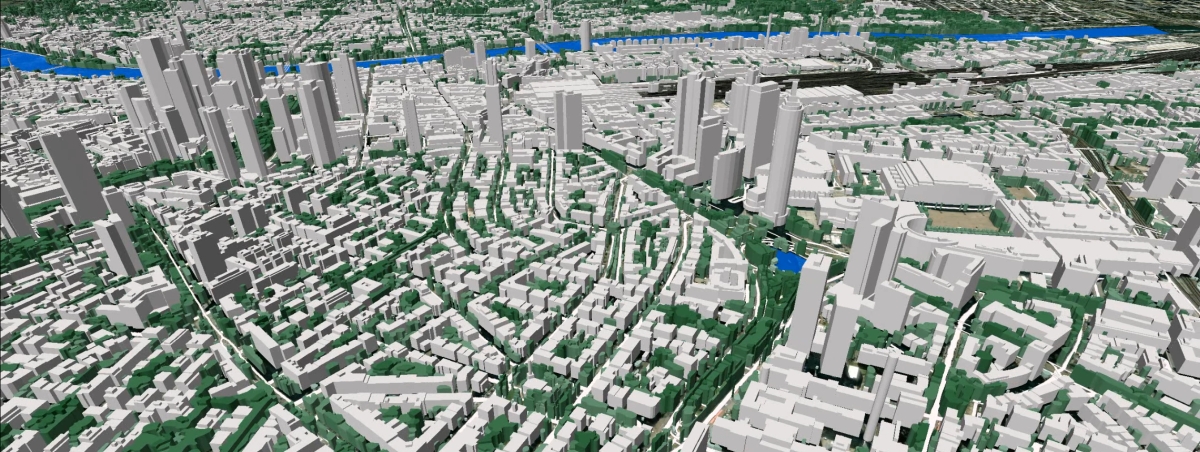
Discover Frankfurt 3D map here (3D view video)
🛠️ What We Offer:
- 3D digital maps for projects of any scale
- AI-powered object detection and analytics using CNN technology
- GIS-ready layers: DTM, Land Use, Clutter Height, 3D Buildings and Vegetation, Road and Railway networks, Population, Addresses
- Custom mapping for Digital Twins, infrastructure, and environmental monitoring
We collaborate with companies across the EU to deliver nationwide 3D coverage and tailored mapping solutions that drive innovation in urban development.
📥 Downloadable Materials:
- Samples of 3D City models formats Atoll: Belgium, Bulgaria, Croatia, Germany, Italy, Luxemburg, Malta, Austria
- Country-specific brochures: Austria, Czech Republic, Greece, Croatia, North Macedonia, Slovakia, Montenegro
- Rome 3D view video
- More videos
- More data samples
🗺️ Available Geodata for European Countries:
Albania, Bosnia and Herzegovina, Kosovo, Lithuania, Moldova, Romania, Serbia, United Kingdom, Austria, Czech Republic, Greece, North Macedonia, Montenegro, Croatia
Available layers: Buildings, Vegetation, Roads, Railways, Administrative Bounds, Postal Codes, Hydrography, Population, Addresses
💡 We Turn Geodata into Solutions
Our data empowers:
- Urban planners
- Energy providers
- Construction firms
- Real estate developers
- Agricultural professionals
- Decision-makers in science, business, infrastructure, environmental and spatial planning
🧠 Digital Twins for Resilient Infrastructure
VISICOM’s mapping technologies enable the creation of accurate digital twins — essential tools for designing, maintaining, and optimizing resilient urban and industrial infrastructure in a rapidly changing world.

